Showing posts with label Travel. Show all posts

Saturday, February 11, 2023

Dekho Apna Megh! - Part 2

 In the previous post (click here), I described my visit to the capital city Shillong. In this post, I write about the other places I visited during the visit – mainly, Mawlynnong, the Krang Shuri waterfalls, Dawki and Cherrapunjee.

In Mawlynnong, our first port of call was a visit to a “Living Root Bridge”. The living root bridges of Meghalaya are a unique and remarkable feature of the state's landscape. These bridges, found in the dense forests of the region, are made entirely of living trees and roots, and are woven together over time to form sturdy, naturally grown bridges.
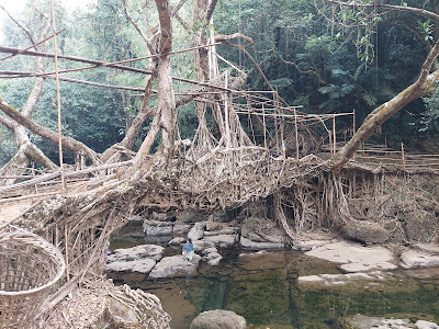
A "Living Root Bridge" - Unique and spectacular.

Meghalaya has several such bridges which are made from the roots of the rubber (“ficus elastica”) trees. The tribal people of Meghalaya have been weaving these roots for centuries to create bridges that can support the weight of several people at once. Living root bridges are not only a fascinating engineering feat, but also an important part of the local culture and tradition. Visiting these is a unique and unforgettable experience. The bridges are located in some of the state's most beautiful and remote areas and are a testament to the ingenuity, creativity, and resilience of the local communities. They are a fascinating example of nature's ability to provide sustainable solutions to the challenges of modern life.

Mawlynnong is also famously known as the "Asia's Cleanest Village”. The village is home to around 500 people of the Khasi tribe. The villagers take pride in their cleanliness and have made it a priority to keep their village spotless. The village is a hub for eco-tourism and offers visitors the opportunity to experience traditional village life while also learning about sustainable living practices. For those having more time, almost every household offers a “homestay” option where visitors can spend a few days. Mawlynnong has received numerous awards and accolades, including the "Best Village Tourism Award" from the Ministry of Tourism, Government of India, and has been featured in several international travel magazines and documentaries.

A street view in Mawlynnong village

We took a stroll at the village, looked around the natural beauty, dined and shopped at the local shops. I tried to speak to a few villagers but found them reluctant to engage in a conversation.

The next day, we headed to Krang Shuri. The Krang Shuri Waterfalls are located on the Eastern side of Meghalaya, roughly between Jowai and Dawki. It’s a pity many tour operators skip these falls, as the location is out of the way from the main tourist circuits of Shillong – Cherrapunjee – Dawki. But these falls are perhaps the most beautiful and spectacular waterfalls in the state and are a “must-visit” site for anyone traveling to Meghalaya. The falls are surrounded by lush green forests, and the sound of the cascading water creates a serene and peaceful ambiance. You get life jackets on rent if you want to take a dip in the (chilling cold!) water. There are changing rooms for tourists. Apart from the view of the waterfall from below, one can go on top of the waterbed from where the stream comes. Tourists can also enjoy boating and watch the scenery around. A visit to Meghalaya is incomplete without visiting Krang Shuri.

The mesmerizing beauty of Krang Shuri is not to be missed

From Krang Shuri, we came to the border town of Dawki, situated on the banks of the Umngot River. The river is known for its crystal-clear waters, so transparent that boats appear to be floating on air. The best time of the day to visit Dawki is around noon, when the sun is overhead and sun rays penetrate right down to the bottom of the river. Visitors can take a boat ride on the river, spend time on its banks filled with picturesque rocks and enjoy the spectacular views of the surrounding hills. Visitors to Dawki can also visit the India – Bangladesh border and snatch a bargain from the garment vendors who walk over from the other side!

Take a boat ride in the Umngot River 

A word of caution here – the roads around Dawki were in bad shape when we visited. Further, they have heavy truck traffic, so visitors should base their time calculations keeping adequate margin in mind. The distances look short on a map, but it takes much longer to reach your destination! Luckily for us, we visited Dawki on a Sunday, when the truckers have a holiday and traffic was far less.

After Dawki, we visited Cherrapunjee, which has now been renamed Sohra. The place is famous for being one of the wettest places on earth. Cherrapunjee is also known for its beautiful waterfalls, bridges and limestone caves. The most popular tourist attraction in the region is the Nohkalikai Falls, which is the fourth highest waterfall in India. The waterfall is located just a few kilometers from the town and is surrounded by lush green forests. The water here falls from a height of about 1100 feet and creates a spectacular sight. Visitors can take a short hike to the viewpoint to get a closer look at the falls and to enjoy the picturesque views of the surrounding hills.

The Nohkalikai Falls is another beauty that will leave you spellbound.

Another important place to visit is the Mawsmai Caves. Mawsmai caves are a network of limestone caves located just a few kilometers from Cherrapunjee. The caves are popular among adventure seekers and cave enthusiasts as they offer an exciting and challenging experience. Visitors can explore the caves and see the interesting rock formations, underground streams, and limestone formations. Besides these, we also visited the Seven Sisters Waterfall, the Eco Park and a few other viewing points in and around Cherrapunjee.

Overall, I spent six days in Meghalaya. It was an unforgettable experience! 

It is said that if humans were meant to be in one place, we would have had roots, not feet. What are you waiting for? Pack up your bags and leave.

Thursday, February 2, 2023

Dekho Apna Megh!

The world, they say, is a book, and those who do not travel read only one page. Well, if we open the chapter called “India” in it, every page will tell a unique story. Last month, I visited Meghalaya, and was left spellbound by what I saw. For a visiting tourist, Meghalaya offers unique sights that you will hardly see anywhere else. What better way to celebrate the "Dekho Apna Desh" campaign than by visiting the abode of the clouds.

Meghalaya, located in India’s northeast, is a state known for its natural beauty, rich culture, and diverse landscape. The state is bordered by Assam to the north and Bangladesh to the south. The name "Meghalaya" translates to "the abode of clouds" in Sanskrit, and the state lives up to its name with its picturesque hills and valleys, often shrouded in mist. 

Meghalaya is home to a population of over 3 million, primarily made up of the Khasi, Jaintia, and Garo tribes. Khasi is the dominant tribe in the state. Each tribe has its own unique culture and traditions, making Meghalaya a melting pot of different customs and practices. The state is also known for its matrilineal society, where property and inheritance are passed down through the female line. Majority of the people are Christian by religion, though I did not find religion playing a dominant role in the society.

The climate of the state is tropical, with heavy rainfall during the monsoon and mild temperatures throughout the year. Cherrapunji (now renamed as Sohra) is known as wettest place on earth.

The capital city of Meghalaya is Shillong, known as the "Scotland of the East" for its picturesque hills and valleys. Interestingly, Shillong was the capital of Assam for almost a hundred years, before Meghalaya became a separate state in 1972. The city is a popular tourist destination and offers a perfect blend of natural beauty and modern amenities. The city is also known for its lively music and nightlife, as well as its colonial architecture and historical sites. It is situated on a hilltop, with narrow winding lanes zig-zagging around single storied houses and street corner shops. The roads are hopelessly inadequate for modern day traffic, and every street has been converted into a one way / no entry street to manage the traffic. The roads are filled with Maruti 800s – perhaps the only cars these narrow streets can accommodate! The city remined me of other similar hilltop-based cities such as Shimla, Gangtok and Mussoorie.

As one approaches the city from Guwahati – the main gateway to India’s North East – one is welcomed by the Umiam Lake. The lake is situated on the outskirts of the city, around 15 km before one reaches Shillong. Surrounded by lush green hills, the lake is a popular tourist spot for boating and fishing. We stopped at the lake, it was sundown time, and the atmosphere was peaceful and serene. The sun sets early in Meghalaya, and in January it was getting dark by 4:30 PM.

The Umiam Lake welcomes you to Shillong

From Umiam Lake, we headed to our hotel in Shillong, and spent the next day visiting popular tourist places in and around the city.

One of the most popular tourist attractions in Shillong is the Elephant Falls - called “Ka Kshaid Lai Pateng Khohsiew” in Khasi, meaning the Three Steps Waterfall. The falls are situated 12 km from the city and offer a beautiful view of cascading water surrounded by lush green forests. The falls are so named because on the side of the falls there was a rock resembling an elephant. The rock however was destroyed in an earthquake in 1897. The falls are a popular spot for picnics and trekking, and there is park nearby which is home to a variety of bird species.

Elephant Falls - the most popular tourist spot in Shillong

Close to the Falls is the Air Force Museum, which showcases the history of the Indian Air Force. The Shillong base of the IAF played an important role in the 1971 war with Pakistan, and one can see artefacts and read stories related to the same.

After the Elephant Falls and the Museum, we planned to head towards the Laitlum Canyon. On the way, we stopped at the Shillong View Point - another popular tourist spot, offering a panoramic view of the city and its surroundings. The viewpoint is located on a hilltop and is a popular spot for photography and sunset watching.

From here, we proceeded towards Laitlum Canyon, which is located around 20 km away from the city. Our driver didn’t know the place, and we spent some time going in circles as Google Maps didn’t seem to show the right route.  A stranger however came to the rescue – search for Smit Valley he said, and we reached the right place!

Laitlum Canyon is said to offer a breath-taking view of the deep gorges and cliffs that have been carved out by the rainwater over the years. But when we reached there, the place was fully enveloped in the clouds! It was quite cold, there was a strong breeze and low visibility. The atmosphere was electric! No views of the valleys but experienced the “abode of the clouds”!

Welcome! - This road goes straight into the clouds!

After the Canyon, we returned to Shillong, and spent some time at the city’s main market, called the Police Bazaar. Police Bazaar is one of the busiest and most popular shopping areas in Shillong, known for its local handicrafts, textiles, and traditional Khasi jewellery. The bazaar is also a great place to try local street food and sample the local cuisine. From here, we returned back to our hotel to rest. The next day, we planned to start early, and go down south towards Mawlynnong and Dawki.

(To be continued…)

Saturday, November 10, 2012

God's own country!


Back from a refreshing trip of Kerala!

Calm and serene backwaters. Tender coconuts. Mouth-watering banana chips. The tempting aroma of freshly brewed coffee. Houseboats. Spices. Rare species of birds. Kadla curry with Appam or Puttu. Pothole-free roads. Disciplined traffic. Long winding village names, which only the Mallus can spell and pronounce! Freshly fried fish. Karl Marx & Che Guevara posters.  Clean white dhoti. Uttapa called as a Dosa, and Dosa simply as a plain ‘roast’! Served along with a Vada that you think is complimentary (till you get the bill, that is). A lake so large you think it is the seaMundum Neryathum, the unique two-piece sari. "Chinese" fishing nets, that actually use Portuguese technology, not Chinese! Beautiful roadside bungalows. Picturesque inland waterways. Ancient "dembles" (!) mostly dedicated to Shiva, holding some of the world’s largest treasure troves known to man. Thundering rains. A quite & peaceful life. Kerala is unique. Kerala has so much to offer.

And a lot more!

Photogenic tea gardens.  Majestic elephants. Ayurvedic massages. Kathakali. Honest autorickshaw-wallahs!  The list can go on…

Some snippets from my recent visit...

Navigating through the backwaters...


The houseboats and the stunning scenery is without doubt Kerala's biggest tourist attraction


The Mahadevar Temple at Kottayam has some stunning architecture on its walls


The unique "Chinese" fishing nets at Fort Kochi


The Bird sanctuary at Kumarakom offers some beautiful sightings 

A mini-Venice, locals around the Vembanad region move around in boats rather than the road


Sunday, July 22, 2012

Peaceful Bulgaria gets a jolt


Bulgaria is a lovely little country of around 7 million people tucked away East of Europe. When I visited the country around 5 years ago, one of the things that struck me as remarkable was the complete absence of any security apparatus anywhere in the country. Being used to the intimidating presence of gun totting security guards, metal detectors and frisking at every nook and corner of the country, the absence of a threat perception among Bulgarians was astonishing.

When I checked into my rented apartment on arriving in the country, my agent – an old lady probably in her fifties - helped me to settle down and showed the place around. At one instance, I had some difficulty understanding the strange locking system on the outer door of my apartment, which she was trying to explain. After a few unsuccessful attempts at teaching me how to lock & unlock the door, she politely said that if I found I could not understand the lock, I could leave the door open while going to office - no one would take anything! I looked at her in total disbelief, but over the next few weeks realized she had really meant it.

Outside the President's Residence - the guards have gone home!
My office, at that time, was located right in the front of the President’s Residence, in the heart of the capital city Sofia. The majestic building stood there almost discreetly, watching life go by. There would only be one security guard at the gate who stood on duty for the entire building. He too would leave at 6:00 PM in the evening and after that, there would be no one! The National Assembly, which stood a stone’s throw away, looked similarly commonplace. You could easily walk up the stairs or take photographs, with no one even casting a glance at what you were doing. No rifle wielding commandos, no cars flashing their red beacons, no VIP cavalcades bringing traffic to a halt. It was clear to me that Bulgarians had no enemies, nothing to fear. Having come out of the Iron Curtain, the country had at that time one of the highest growth rates in Europe and was looking forward optimistically to joining the European Union. 

In fact, the only time I saw any security presence in the country was when the then U.S. President George Bush visited Sofia. For his visit, some of the principal roads in the city were cordoned off, traffic was diverted and there were policemen all around. The night before Mr. Bush was due to arrive, as I walked home late from office, a policeman stopped me and asked for my identity. After showing him my papers and answering a few questions, I proceeded home. Clearly, Mr. Bush had enemies, though the Bulgarians didn’t.

Last week, a powerful bomb ripped across the coastal city of Burgas in Eastern Bulgaria, killing 5 Israeli tourists and injuring many others. The tragic attack has shattered the peace and harmony of this beautiful country. If the attack changes this permanently, it would be a sad day indeed.

Saturday, May 26, 2012

Buddham Sharanam Gachhami !


Long before India started exporting spices or software, Ideas, Thought Leadership and Spirituality were the earliest exports from India to the world. The zero and the decimal system, which forms basis of the numbering system that the world uses today, was invented in India. Kautilya’s Arthashastra, written in the 4th Century BC, laid down the principles of governance, public administration and taxation several centuries before modern-day economics or political science was born. Wonders of modern science, from aircrafts to surgeries have all been mentioned in ancient Indian texts. Ayurveda holds the secrets of good health which modern day researchers are trying to discover and patent. Sushruta’s Sushruta Samhita, written in 800 BC mentions more than 300 surgeries, including the likes of plastic surgery, cataract and caesarian section. The techniques of Yoga and Meditation as key to a healthy body and a healthy mind are seeing resurgence in the West.

Grand Buddha statue at the pagoda
One of the ideas that India gave birth to, and were embraced by the world, were the teachings of Gautam Buddha. From Mongolia in the North to Sri Lanka in the South, and from South East Asia to Japan, Buddhism is today the fourth largest religion in the World. Close to half a million people in the world follow Buddha and his teachings as their principal religious order.

Buddha taught that suffering is an ingrained part of existence, but it is possible to end it by following the right path. The right path, he said is the eight – fold noble path of right view, right intention, right speech, right action, right livelihood, right effort, right mindfulness and right concentration. Buddha said no teachings should be accepted unless they are borne out by our experience and are praised by the wise. Buddha held that two qualities are rare among humans: Katannuta that is, Gratitude and Pubbakarita, which is, initiative to help others without expecting anything in return. These two qualities are the true measure of progress.

A grand Pagoda, styled along traditional Burmese architecture, has come up in Mumbai recently.  The pagoda, built by the Global Vipassana Foundation seeks to spread the true teachings of Buddha and  promotes the practice of Vipassana Meditation that was said to have been practiced by Buddha himself.

The Pagoda claims to contain the largest pillar-less dome structure in the World, 90 feet in height and 280 feet in diameter. Built using 2.5 million tonnes of stone and 3,000 truckloads of sand, the pagoda towers to a height of a 30-storey building. Underneath it is a huge meditation hall which can accommodate 8,000 people at a time. It has been designed as a replica of Shwe Dagon Pagoda of Myanmar. Relics of Gautam Buddha are enshrined at the site. The entire complex, apart from the main pagoda, contains several other structures such as an art gallery, a library, two other smaller pagodas, an auditorium, a food court etc. Exquisite samples of traditional Burmese architecture can be seen throughout the campus. The art gallery contains stunning paintings depicting the life of Gautam Buddha from birth to death. An excellent facility, to listen to the story of each painting as you move along the gallery, using a tape and earphones is available. This makes the visit to the gallery worthwhile and meaningful, as it enhances our understanding of the life of Gautam Buddha and his teachings. The pagoda is located off the coast of Gorai, in Mumbai. Take a look some day.


Tuesday, May 15, 2012

A surprise called Nagaon


I have always been enchanted by beaches. Every beach has something new to offer, something different. I find it difficult to explain what it is – is it the water, the sand, the fresh breeze or the sun? May be the clouds, or the trees around. There is always something new, something different to see and experience. I wonder if there is a “beach therapy” around. Going to a beach is a medicine in itself. Nothing rejuvenates better than a visit to the beach.

So when a friend suggested we go to Nagaon for the weekend, I was only too willing to join. A few glimpses from my visit to Nagaon, which incidentally must also be the cheapest water sports centre near Mumbai.


Set sail from the Gateway


Mandwa is just an hour away
Can we see Vijay Dinanath Chauhan anywhere?

Can you see a Ganesha here?
The journey is a ship watcher's paradise - click here for more

Surprisingly high tides, right on the shore make Nagaon a delight for sports lovers


Enchanting sunset makes the visit unforgettable!

Sunday, March 18, 2012

Fort Raigad - worth a visit


Chhatrapati Shivaji can undoubtedly be counted as one of the greatest kings of India. Starting with conquering Fort Torna at the tender age of 16, Shivaji took on the combined might of the Mughals of Agra and the Adilshah and the Nizams who ruled the Deccan Plateau. His daring exploits, such as the stunning escape from captivity from Agra in a box carrying mithai, to the conquest of the dreaded Afzal Khan, far taller and stouter than him, in hand to hand combat can easily fit into a Bollywood storyline. At its peak, Shivaji’s rule covered parts of the Deccan plateau, and extended South to modern day Karnataka and spread as far as Jinji and Vellore in today's Tamil Nadu. Shivaji was recognized not just for his brilliant battlefield tactics, but also for his extraordinary benevolence. Stories of his generosity and large-heartedness have been documented by several people, including foreign travelers who passed through India during his time. Shivaji’s conquests laid the foundations of the Maratha Empire, which the Peshwas eventually extended from Panipat in the North (today’s Haryana) to Tanjore in the South (Tamil Nadu).

The ropeway has made it easier to visit the Fort
I recently visited Fort Raigad, the seat of Shivaji’s power where he was coronated in 1673. The Fort is at a distance of around 200 km from Mumbai, a 5 hour drive on the Mumbai – Goa Highway. Located in the midst of the towering Sahyadris, at a height of around 2700 feet above sea level, Raigad makes for an outstanding weekend gateway for the tired Mumbaikar. You can take your car right upto the foot of the mountain, from where a private ropeway carries you to the Fort in a few minutes.

Architectural photographers will love the place
The main Fort, spread across an area of almost 100 acres is now largely in ruins. You can hire Government empanelled tourist guides, who parrot their prepared text and take you through the important places of tourist interest. Among these are the palaces of Shivaji’s six (of the seven) queens, the durbar, the granary which also doubled as a prisoner’s cell, and the main bazaar. A grand statue of Shivaji, erected in recent times, serves as the perfect background for the customary photo op session. At one end of the fort is a Shiva temple. Shivaji’s samadhi, where he was cremated on his untimely death in 1680 lies next to the temple. Its almost ordinary façade tells its own story, one of governmental neglect and lost tourist potential. The more adventurous can walk across to places like the Hirkani buruj or the Takmak tok (point) to get a glimpse of surrounding mountains. On your return, you can dump the ropeway and even walk down the 1500-odd stairs to view the main entrance to the Fort.

From the Fort, you get an extraordinary view of the surrounding valleys and mountain ranges. The Maharashtra Tourism Development Corporation (MTDC) has a few rooms for overnight stay, and in fact, this is what makes the place worth your visit. For, the best time to visit the Fort is from dusk to dawn! When the sun begins to set, the day tourists have gone back, and cool breeze begins to set in. As it gets dark, you can listen to the wind, watch the stars and simply amaze at the pitch dark sky!


The fort gives you an excellent view of the Sahyadri Mountains


Magical moments - around the sunset & the sunrise

Sunday, January 15, 2012

The Jarawa debate: Is backwardness "culture"?


The Jarawa tribals of the Andaman were in the news this week. A news video put out by The Guardian showing Jarawa women and children dancing in front of the camera for the benefit of tourists caused uproar in the country. Local media picked up the story and the Government has now ordered an enquiry.

The Jarawa are one of the four Negrito aboriginal tribes inhabiting the Andaman Islands. Their total population is said to be just around 250 or so. These tribes are said to be among the direct descendants of man’s earliest ancestors who migrated from Africa around 65,000 – 70,000 years ago. As late as till the 1990s, the Jarawa were said to be living in their forests in complete isolation and had resisted all contact with outsiders. But in the last fifteen years, the Jarawa have gradually shed their isolation.

I first heard of the Jarawa during my recent visit to the Andaman Islands. On our way to the Limestone Caves in North Andaman, our bus passed through the dense tropical rain forests of Middle Andaman, home of the Jarawa tribes. We passed through these forests escorted by a police convoy. The vehicles were not allowed to stop for a stretch of about 50 kilometers till we reached the other end of the forest. On a couple of occasions during our journey, the Jarawa came close to the passing vehicles, providing a glimpse to the shocked tourists. Their faces were painted yellow and they wore nothing.

This notice pasted in our bus said it all. Though unscrupulous tour operators need to be dealt with severely, there is no reason to deny Jarawa the benefits of modern development 

The construction of the 300-odd kilometer long Great Andaman Trunk Road that runs north – south through the length of Andaman and through the heart of the Jarawa inhabited forest has opened up an opportunity to integrate the Jarawa into the national mainstream. In fact, the Jarawa have now started to venture out of their forests, initiating contact with human civilization. Though extremely hostile initially, the Jarawa are reported to have turned friendly in recent years, asking for food or even medical aid with villagers and farmers living on the fringes of the forests.

But it is unfortunate that some NGOs and environmental groups have been fighting for the closure of the Road, demanding the Jarawa not be ‘disturbed’ or ‘their territory’ not encroached upon. Terms such as ‘human safaris’ used liberally in the media have unnecessarily sensationalized the issue. The Jarawa deserve the benefits of progress and development as much as any other people. Keeping them backward and in isolation in the name of ‘preserving their culture’ is clearly not the way to go.

Saturday, December 31, 2011

Amazing Andamans !


It is that time of the year when one tends to sit back and reflect on the year gone by. Some wishes fulfilled, some others carried forward to the future. These become resolutions for the next year.

For me, one of the highlights of the year gone by was undoubtedly a visit to the Andaman Islands. A completely chance meeting over the internet with a long lost friend who is now in Port Blair, and the next week I had landed there, wife and kids in tow, for a trip he said ‘you will never forget in your life’.

Little did I know how true these words would be. After all, how much excitement can you pack in a single week? 

Stunningly beautiful islands with water as clear as mineral water. 
Thick tropical rain forest with trees towering tens of meters above ground. 
Limestone caves standing still since the beginning of time. 
An aboriginal race that takes you back to the origins of Homo Sapiens. 
Snorkeling, undersea corals and a glimpse of the exceptionally beautiful marine life. 
Amazing mangroves and strange trees like you have never seen before. 
First hand stories of the Tsunami. 
A luxury boat cruise. 
Japanese bunkers dating back to World War II. 
A British era jail where conditions were so harsh that its inmates wished for death. 
And much more, Andaman even has India's only live volcano.

Andaman has so much to offer. It turned out to be a place like no other I have ever visited.

Andaman has things you will not find elsewhere

Grub Island, one of the 572 Islands that form the Andaman & Nicobar Group of  Islands

Rhizophora Mangle roots grow up from the ground and reach the tree  top !
Trees such as the Andaman Padauk grow taller than a ten-storied building
The Limestone caves takes you back to the origins of the Earth
The Cellular Jail is the harshest chapter of India's freedom struggle. Don't miss the Sound & Light show here.

Saturday, September 24, 2011

Sikkim and me


An earthquake of magnitude 6.9 on the Richter scale hit Sikkim this month, bringing back memories of my visit to Sikkim in this same season last year. Reports suggest hundreds of people have died, with inaccessibility of the region and difficult terrain hampering rescue operations. In several cases, entire villages have been obliterated, leaving no one around even to count the dead.

“Inaccessible” is a gross understatement. Sikkim has no Airport, though one is currently under construction. The state has no railway, not even of the “toy train” variety that the British built in places like Darjeeling and Simla more than a century ago. There is only one road – the NH 31A – which connects Sikkim to the Indian mainland. This road is a two lane ‘highway’ that winds its way along the Teesta river, giving you breathtaking views of mountains & valleys at the foothills of Himalayas. Even at the best of times, there are frequent landslides that block the road and bring traffic to a halt. People then wait for the Army to arrive and clear the road, so that the traffic can resume. Monsoons are, of course, worse. At times, you may have to spend the whole night in your car till the road clears, but no one complains. People have resigned themselves to their fate.

The epicenter of this quake was said to be near Mangan, a small town north of Gangtok. I passed through Mangan on my way to the magnificent Yumthang Valley, on the Indo – Tibet (now China) border. Yumthang lies at a height of more than 14,000 feet above sea level. The entire region is controlled by the military; you need a permit to enter the district. As you go higher and higher, civilization becomes more and more sparse. At one stage, we were more than 25 km away from the nearest village.

I traveled to Yumthang with 7 other strangers in a hired jeep. The road was dotted with extra-ordinary sights - thick green forest, deep valleys and stunning waterfalls. At several places, the road was ‘broken’ (monsoon hai!) and descended into a kachcha road of mud or stones (see the attached video which I took from my car for the condition of the roads there). At times, we suddenly encountered steep ascents, so steep that the car would not climb. The driver would then ask all passengers to get down and walk up the climb, while he would just about somehow manage to take the car up, sans the weight of its passengers! At several places, we made way THROUGH the flowing waterfalls – water falling down from several meters above us on one side of the vehicle, crossing the road in front of us and the falling down to the other side, hundreds of feet below into the deep valley! It felt as if any moment the car would be thrown away, down the deep valley on the other side. It was a frightening experience, and yet a memorable one! At one place, our car got stuck deep in the mud and all of us had to get down and push it out to get going! All this, in a desolate forest, several miles away from civilization at a height of several thousand feet.


On the day of my return from Gangtok, I almost missed my flight. All exit routes going out of Gangtok were closed as it had rained the previous night and there were landslides everywhere! We spent four hours searching for ‘a way out’ of Gangtok. I started ten hours in advance for a five hour journey, and reached the check in counter five minutes before it closed!

To get a glimpse of the beauty of Sikkim, click here.

Tailpiece: There are no petrol pumps anywhere in North Sikkim. Fuel is sold in grocery and general stores. On enquiring about this strange thing with our driver, I was told that fuel from military vehicles is sold by the personnel to these shopkeepers at a discounted price. The shop owners then add their own margin and sell to others. So much for tax payer’s money!